We’re less than a month away from the release of Tempered, the second book in the Scorched trilogy. Fans of This Corner of the Universe know I’m a “map guy”… the TCOTU galaxy is well over 100 worlds and will continue to grow. In contrast, Kat’s environment in Scorched and Tempered is far more intimate.
After the events in Scorched, Kat begins to realize there is more than just Waytown and the “shattered planet” opens up a little. The first thing I did when outlining and brainstorming the rest of her story was create a map of the “playground” of the Scorched series:

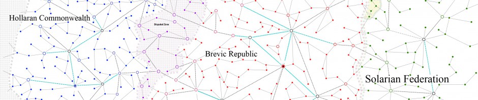
(click for larger view)
The map is by no means a complete depiction of Kat’s world, and I reserve the right to change details right up to when I release Tempered (then it’s canon I have to live with). But, I like giving sneak previews to readers dedicated enough to follow my blog.
The unfilled circles are towns such as Waytown. These are relatively low-tech settlements that essentially grew up to support an important industry (whether it be mining, like Waytown and the settlement in The Red Desert, or agriculture such as the town in The Eastern Expanse). Light grey circles are abandoned settlements. The community south of Waytown didn’t fair so well. Neither did the very small village between Northport and Waytown.
The black diamonds are cities, perhaps ranging into the millions of citizens and having comparatively better technology. These are the major manufacturing centers, the places everyone wants to live. We’ll definitely be touring Coldbarrow and the capital, Northport, in the series.
If you look closely, you can see tiny black dots representing actual mining and agricultural locations. Recore Mining is nestled in the mountain east of Waytown and the spur that Kat’s mag-rail takes to transport her to work is marked near it. Dark lines are mag-rails, the primary long distance means of transportation. The light grey lines are actual roads.
Region names were developed to give a general impression of those parcels of land. The Blight is evocative of a dry, burned wasteland. The Shores hopefully provides the reader with images of a more fertile, green land touching the sea. The Red Desert suggests an image of something like a red Tatooine from Star Wars. Finally, the Eastern Expanse should provoke the flat, nearly endless plains of America’s heartland (although the exact setting of this story hasn’t been pinpointed).
Creating this map helped the setting become real to me and from there, I was able to visualize places and make connections between locations and settlements. Drawing a map helps me create a living, breathing world that becomes its own character. Certainly, Waytown should feel different than Coldbarrow, and so forth. From these humble dots and lines, vibrant towns emerge with marketplaces, hospitals and more.
